Change Detection has become a buzz-word in conversations about satellite analytics and location intelligence. This technology is romanticized and is oftentimes perceived as an all-seeing eye and a panacea. But is it really? Let’s set the record straight and clarify the purpose of change detection, its value, as what is still beyond its capabilities.
Change detection
Before looking at the ways environmentalists and companies can utilize Aspectum, let’s cover fundamentals by answering an important question: what is change detection? In the geospatial analysis, it is a method used for identifying differences that occurred in a certain area (known as Areas of Interest, or AOI) within a certain period. With the help of this method, professionals from different fields can monitor deforestation, ice glaciers melting, volumes of crop tillage, etc.
The Capabilities of Change Detection:
This method has a wide range of applications and can be used to solve different tasks. Here are some questions that can be answered with the help of change detection remote sensing:
- What has happened to the location? Change detection gives insights into what is different in a certain area over a set period, especially when the purpose of a site is altered.
- What has moved? Experts can monitor the movement of objects on the AOI.
- What has become reshaped? By comparing photos of an area, you can see how the shape of the area varied over time. This is useful for studying habitats, forests, and water basins.
- How has the object’s size changed? This helps to monitor if a production site, crop field, or natural park changed in size within a selected time span.
Normally, specialists can perform change detection analysis manually or with the help of neural network algorithms. However, a manual approach is out-of-date, whereas neural networks need training. Aspectum offers a solution, where you can instantly access an image, related analytics, visualization, and a user-friendly dashboard with widgets. This is what sets Aspectum apart from other solutions for geospatial imagery analytics, where users receive only an image with some uninformative and at times confusing marks. Aspectum provides users with changes in vast areas and the midpoint, and compares it with other territories. Such capabilities are especially valuable for detecting unlawful land use.
What Changes Aspectum Detects
As a sophisticated solution for GIS analytics, Aspectum possesses vast geospatial datasets. Specialists can easily and effortlessly use remote sensing data to detect the changes in AOIs for different purposes:
Deforestation
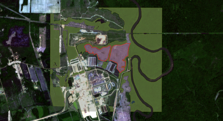
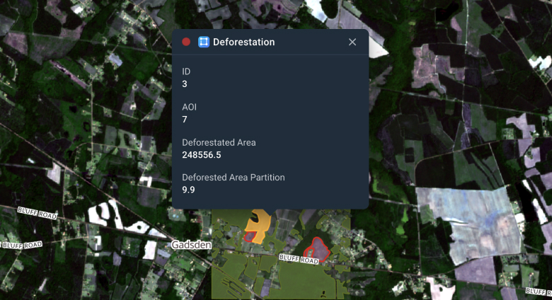
Sentinel satellite imagery comparison helps evaluate the extent of deforestation by calculating changes that a forested area underwent. Analysts can apply categorical filters and display a summarized area of forest cover and deforested area. This data provides insights important for monitoring forest covers and planning replants.
For instance, this deforestation map compares forest cover in February and May 2020 in Columbia, USA. It demonstrates vividly the changes that the terrain had undergone due to deforestation.
River diversions
Also, comparative analysis can help study the state of rivers. The overtime analysis of imagery reveals not only the changes in depths but also how much they diverted. On top of that, the imagery will provide a clear perspective on plantation development in certain areas around rivers.
Quarry landscapes changes
When mining resources, the focus is on productivity. And the impact on nature is oftentimes neglected. Meanwhile, arrays of plants disappear, habitats get ruined, biodiversity is reduced. Aspectum change detection software assesses the size of the problem to reduce the damage and to plan better in the future.
Wildfire damage assessments
Aspectum provides effective tools that help to estimate fire spreading and to minimize risks. But also comparing satellite imagery of AIOs helps to evaluate the damage from burning, identify the most affected areas, and restore them.
When Change Detection is not the best fit
Despite being on everyone’s lips, change detection may not be the optimal choice for a number of tasks. When it comes to tailor-made projects, we are trying to show diversity of monitoring options before customers start.
Satellite Imagery vs Drone Monitoring
Monitoring of construction is a quite common focal area when we are talking about change detection. However, does it really make sense to watch the progress using satellite imagery? Isn’t it cheaper and more comfortable to use drones instead?
Better choose Satellite Imagery, when
- the monitored area is under drone flight restriction;
- there are any risks of drone theft or damage;
- the monitored zone is large;
- historical imagery is needed.
Better choose Drones, when
- everyday imagery has to be taken;
- the monitored zone is located in the heavy-clouded area;
- monitored zones are very small, as the minimum image request for satellite imagery might be about 50-100km2 (depends on a provider).
And no worries, you can visualize imagery analytics in Aspectum both from drones and satellite (WMS).
Change Detection vs Field Survey
Some of our customers prefer building their tailored maps for field surveys to change detection visualization. This pattern is quite common for agrarians that have dedicated scouts for fields. The key point here is precise data.
Satellite imagery’s most precise resolution is about 0.4 m. Drone can fly as low as 75 cm above an object. However, a person can lean down to the particular leaf and make a photo of a small yellow dot on it. And then send that using Aspectum’s data crowdsourcing bot. It will appear on the tailored map in a few seconds.
Field survey is better, when:
- you have a dedicated scouting team with additional field tasks;
- the proposed algorithm of detection is not perfect: for example, monitoring of small landfills;
- part of the work is done at an underground level, such as utilities monitoring.
On the other hand, change detection:
- works in hard-to-reach remote areas;
- eliminates the human factor;
- is altered for different surface types.
We haven’t listed the price comparison for a reason. It depends on wages, tasks, data update frequency and preciseness. However, you don’t have to be an expert here. Just address our account managers, and they will help you with a detailed calculation.
Aspectum in business
Numerous organizations have already implemented Aspectum to monitor environmental changes for making informed decisions and making sure their development is sustainable. With the help of Aspectum, companies can view different regulations in each region. This helps the decision-makers to keep in mind the requirements for environmental protection while carrying out their business activities.
Furthermore, change detection has become in demand by organizations for such environmental planning capabilities as forecasting of changes pushed by human activities, assessment of natural resources, reducing the effects of oil spills and pollution, preserving and restoring forestry canopy, and more.
The damage to the environment has been big enough. Waiting any longer only exposes our world to greater risks. To respond to the threats adequately, we need to see the full scale of ongoing processes. Aspectum change detection is a powerful instrument that provides such insights to respond to environmental threats appropriately.
Why choose change detection visualization in Aspectum?
- We personally check algorithms used for change detection tasks instead of dealing with providers with mediocre quality of analysis.
- We help with choosing the satellite imagery provider for your particular needs.
- We transform imagery and algorithms into readable and actionable data. Therefore, our dashboards bring clear value. The result of the change detection case can be easily integrated into your digital lab, municipal portal, or any other web page.