Object detection is a completely innovative technology. People could only dream about it centuries ago. Nowadays, its immense contribution enables businesses and governments to enter the new level of their development. With object detection, large-scale monitoring and advanced analytics get fulfilled considerably promptly while the optimization of previously challenging tasks allows data-driven decision-making.
What Is Object Detection?
First and foremost, this computer technology emerges as a key solution to data visualization. It relies on machine-learning algorithms and artificial intelligence tools which process digital images. Identified objects are divided into semantic groups depending on their common features. Object recognition also allows counting and labeling humans, items, buildings and animals. The system indicates the level of accuracy and detects object location.
Opportunities to Use
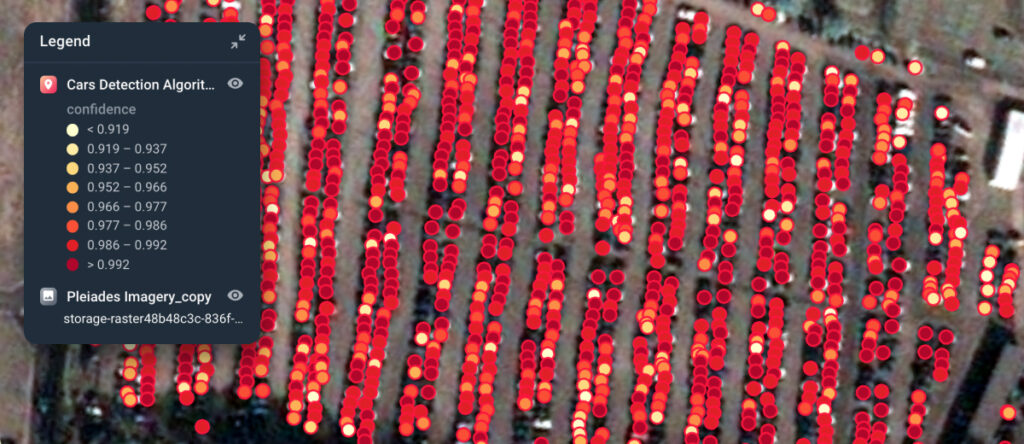
As a critical component of advanced technologies, object detection is a multi-faceted tool that provides ample opportunities for different spheres. It apparently abounds in numerous benefits, but what are the ins and outs of its implementation? Enriched satellite imagery with vector-based visualization creates analytical insights via imagery processing to run car detection, building detection, and disaster detection operations.
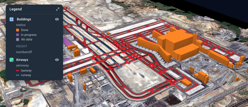
Recognition comes in handy in the housing sector and urban development. The model is used to detect human settlements and industrial buildings. Based on the analysis of satellite images, city planning and development are run feasibly and cost-efficiently because companies can monitor the location in detail to assess the volume of work.
Moreover, the effectiveness of object recognition for disaster detection operations cannot be doubted. Satellite images identify areas with damages and help to look for people there. With object recognition, even the smallest debris can be detected so that victims of disasters or accidents are released more safely.
Through the Client’s Eyes
Aspectum is the only solution on the market that combines GPU-based analytics, best-in-class visualization and satellite basemaps on demand. With deep learning techniques, visualization of satellite data facilitates analyzing landscapes and detecting objects depending on the set goals. The recognition of houses, commercial buildings, cars and moving objects is a useful tool with constant improvements. To proliferate this technology means to integrate algorithm-driven solutions in business and optimize the workflow with the most suitable means.
Here are two approaches on how to use object detection.
Do It Yourself
This approach involves direct work with a neural network and completely relies on the customer’s data. The own satellite images or aerial drone images are processed with the existing neural network. Otherwise, customers can create the new one and adjust it to analyze images depending on the location. If the object detection works effectively, for instance, in California, it can also identify objects in Michigan. However, users should teach neural networks on how to process multiple images from the same area.
Object Recognition algorithms are usually color-dependent. That changes the game when you need to detect roofs or trees. As a result, technology enables users not only to detect the desired objects but also to identify their types. Yet, specialists should perform clusterization, outliers, and the like on their own. It’s an elaborate process that involves one or several service specialists. What’s more, they will use about 2-4 software platforms from purchasing a snapshot to working analytics.
Turnkey – No Code Solution
This approach comes in handy when objects should be detected, but there are no IT resources for the project. For instance, it can be the preparation for a presentation on the new master plan, optimization of infrastructure within the state, or other state and transport initiatives. For this custom-made work, clients define the area for monitoring and types of objects that should be recognized there. To deal with other functions, specializing companies are hired. As for Aspectum, it offers numerous solutions for snapshots processing, detection, visualization and structural analysis.
Myths about Object Recognition
#1 That’s an easy 1-click operation.
Actually, it’s further from the truth. Brochures and articles about the technological future often depict a swift work with satellite imagery analytics. It’s nothing but an exaggeration. To yield outputs, users should necessarily pass the following steps: data preparation, algorithm training, data processing, data post-processing, visualization.
#2 If you have any satellite image you can detect what you want.
1 meter is the optimal image resolution to identify roofs. For cars, it’s 0.5 meters. Accordingly, free 10-meter images are categorically inappropriate because it is difficult to recognize something there. Yet, agricultural fields are an exclusion.
#3 Cheaper by the dozen.
Not certainly in that way. If you order object detection based on satellite images for small sites in different parts of the country, then it will be more expensive than for several locations close to each other. This is due to the pricing policy of the image providers, which offer prices for a minimum area. For different regions, the minimum areas are summed up as they are parts of different images.