How Companies Are Actualizing Their Full Potential Through Geospatial Analytics
The way we process data is no less important than how we get hold of it. In times when information can be so plentiful, analyzing and making sense of it – is the new issue. Among many, it is tackled by Geographic Information Systems or GIS.
In the past GIS was an exclusive technology adapted for a limited circle of specialists. Now, as the value of geospatial data is seeing exponential growth, the ways to process it are adapted for wider audiences and new usage scenarios.
Here are the main industries to reap its benefits in the nearest future:
Retail
The history of large retail businesses graciously provides many case studies on dynamic growth. Not all of them are success stories, however, as a lot of them have been trying to expand without sufficient analytical effort guiding this growth. The result is what’s commonly referred to as the Retailpocalypse with 12,000 physical stores shutting down ever since 2010 and up until today.
As of right now, 28 huge retailers are borderline filing for bankruptcy. When opening new stores in your network it is actually possible to both be methodical and bold at the same time. It’s using data to guide your decision making.
There is major potential hidden in GIS. Here is what it can do for you:
- Map-based marketing campaigns
Geospatial insights may be the missing link to the complete image of your targeted audience. They will grant you the precision to aim at your future leads selectively and focus the exact people that you need.
- Competitor coverage research
Build a map of your peers’ locations and their economic potential. By analyzing the competitor network you’ll be able to calculate their impact and find new potential areas for yourself.
- Choose new locations for your retail network
There is always more to choosing a location for a new store or branch. A geo-based map with multiple layers of data is absolutely essential for the matters of location choice. The challenges like these are exactly why GIS was created in the first place.
- Logistics planning
Moving the stock and supplying your customers with goods is a resource-intensive process. Layering data into your delivery routes is going to reveal new knowledge to optimize your fleet paths and boost ROI.
- Demographic mapping
The data on your client personas is everywhere. Organizing it into location-based insights will show the geography of your audience. You will see how things like gender, income, and age ratio are distributed in terms of your operating area and be able to work it with more finesse.
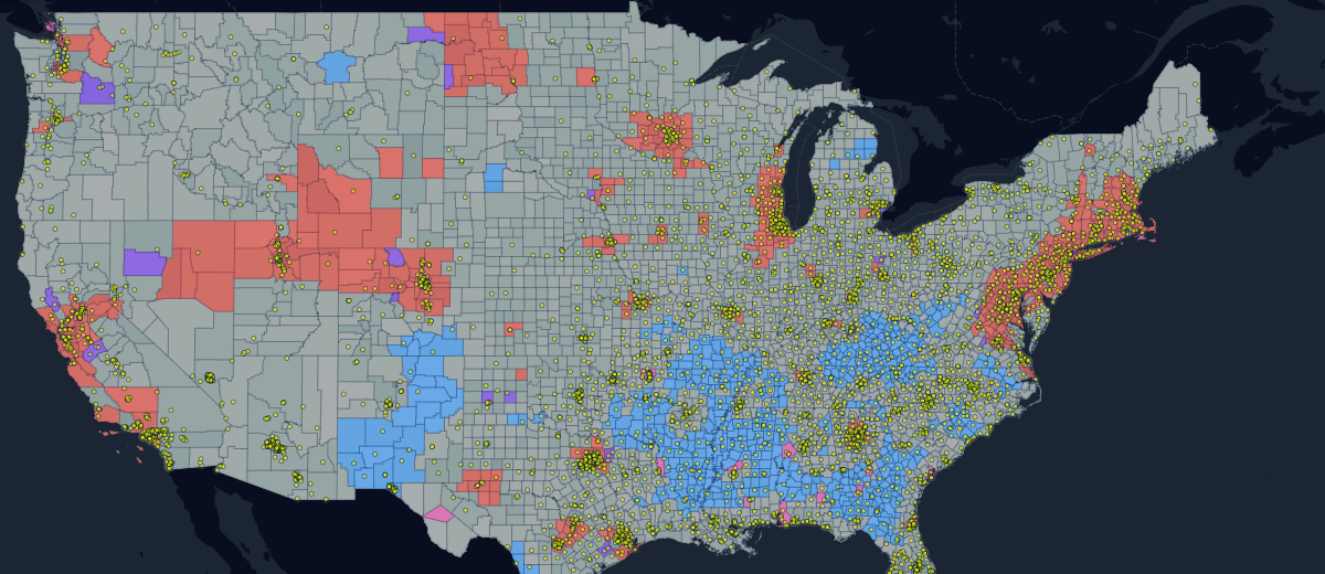
In practice, this can be seen through our template map of Walmart. It shows the distribution of stores within the US with population income shown per specific areas. The least and the most wealthy areas are shown with blue and red hues.
It reveals a myriad of factors that speak about store profitability and economic potential per region.

Smart City
As it is with many bright ideas, the concept of a smart city has preceded its implementation for very long. Now innovation has reached a point where, in many areas, it’s finally possible.
Each city is an infinitely complex organism that poses a major challenge in terms of management. Today, Information technology and GIS, in particular, allow to faithfully recreate an urban environment. Things like population stats and infrastructure can be displayed over the map to divide into categories that are easy to manage.
- Visualized city data as a public service
With GIS you can keep the population informed on how to navigate and use everything the city offers. Third-party online maps can be used to create workarounds for issues like traffic jams and do much more.
- Optimizing disaster management
Response times of vital community services can mean the difference between life and death. Data on demographics and other aspects will reveal how to improve the coverage for these incidents and address them in a more integrated fashion.
- Improving infrastructure
Precise area maps provide specified data on population dynamics. They show how different areas are supplied in terms of amenities and indicate ways to make the city more comfortable for the people.
- Introducing major changes in a moderate fashion
Need to introduce a subway system or build a new road? Geospatial analytics will let you plant new objects exactly where they are needed and embed them into the infrastructure in a compatible fashion.
Real Estate
Real estate market is no stranger to GIS. Just like many other industries, it is already using spatial analytics to a certain extent. This is basic location mapping and, sometimes, aggregation of third-party data from multiple listing services with IDX.
As innovation is opening new possibilities, the list of scenarios for GIS keeps growing. The data becomes more available and geospatial analytics become more powerful thus creating demand for user-friendly solutions that drive improvements.
- Improved market insights
You can use open-source data together with MLS to build data-rich region maps that hold complex analytics such as area-based market situation combined with available properties and many more. Today, the technology finally allows you to make this complex information available not just for GIS specialists themselves but for business experts as well.
- Powerful spatial awareness for residents
Local living conditions are immensely important in real estate price formation. The profile for each property comprises a complex roundup of factors. This is the quality of air, overall noise levels, easy availability of public transport, green areas and more. These can now be factored in to create property/area profiles that are true to life in terms of their situation.
In particular, with our map of Kiev, you may see a great multitude of mapping layers. In addition to the categories mentioned above, they include many sophisticated datasets such as availability of parking spots and infrastructure.
- Easy depiction of complex data
Huge forked datasets can be hard to wrap your head around. Layering them on top of an area will do a lot to improve on this issue. Doing so will make reports understandable for varied teams of experts, stakeholders and clients.

Geospatial Data That We Deserve
In our fast-paced and transparent world the data is plentiful. Knowing how to use it in a positive way is becoming the next frontier for business strategy. Technology finally lets us convey complex ideas in with vivid visuals and the pinnacle of this charting is seen through the recent progress of GIS.
The data is empowering, and presenting it both visually and accurately will decide who is going to get the most value from it.