Explore how industries use Geographic Information Systems and Business Intelligence to make better-informed decisions.
Geographic information systems (GIS) and business intelligence (BI) evolved in separate silos for many years. But what if you could combine them and take your use of company data a step further?
Bringing the location dimension to a BI solution helps companies improve productivity and cut costs like never before. While both geo-information systems and BI tools are leveraged for data analysis, there are certain areas when using GIS brings better value. But first, let’s examine the difference between them in the context of business analytics.
Business intelligence processes and tools help businesses to transform raw data into helpful and easy-to-apply insights that power business decisions. Geographic information systems digest and present information in a rich, visual, and practical way, detailed down to a street address or a particular warehouse. But what happens when both technologies join efforts?
The result would be a next-level analytical framework that would apply geospatial data and enrich decision-making. From logistics to construction and marketing, the added layer of geospatial data on existing BI helps in these (and many other) business cases:
- Insurance: Forward-thinking insurance companies use geo data to create continuous rate areas based on economic conditions in the area of interest, no artificial boundaries such as ZIP codes.
- Real estate: Companies use it to account for current real estate asset value, demographics, and geographically influenced risk.
- Manufacturing: A material manufacturer uses GIS integrated into the BI-based warranty system to justify damage claims. Climate characteristics can be used to predict areas of risk.
- Sales force management: When GIS analysis is applied to BI-managed CRM software, it helps to balance sales territories coverage with facilities and personnel information.
- Manufacturing supply chain management: Thanks to the graphing and network mapping capabilities, GIS helps to quickie identify problems in product supply and reroute production to another facility to avoid bottlenecks.
- Product delivery: While business intelligence provides easy access to inventory and CRM data, GIS helps to further streamline the truckload and makes shipments more efficient.
- Fraud detection: By using geospatial analysis software, credit card issuers can validate transactions by mapping the user’s location. For example, if a payment was made with the card in one country while the user is located in another, GIS can trigger an alarm about a suspicious transaction.
In many cases, geo-powered business analytics offers more comprehensive and visual insights. For example, you want to create a concept of an open-air social event that would be close to the main transit routes and residential areas and still far enough from healthcare, educational, and childcare facilities to minimize noise. Business intelligence solutions cannot offer enough data for efficient decision-making, but a GIS tool does. Using the Aspectum GIS mapping software, a business analyst can pick the required spots on the map (in this example, this would be hospitals and childcare facilities), indicate the residential areas and even public transit routes, and get several suitable locations for the open-air event.
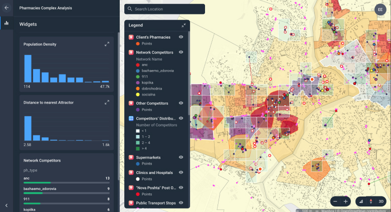
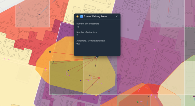
Here’s another example. A pharmacy brand needed to identify the best territories for expansion. The smart mapping combined and digested the data about existing pharmacy networks, competing chains, population density by region, the rental price for commercial real estate, and target audience locations. The result? Right on the map, the business analyst can filter the areas by population density, distance to the nearest pharmacy, or search by a specific competitor brand to find the most profitable locations for new branches.

Here are the main things which enable GIS to deliver location-specific business intelligence:
- GIS software simplifies business intelligence and delivers results without a whole suite of BI tools. The user simply uploads the dataset, picks the desired visual output, and shares the link to the data-rich map with teammates.
- Advanced GIS SaaS, such as Aspectum, leverage high-resolution satellite imagery which is out of scope for business intelligence capabilities.
- Unlike singular BI data points, GIS relies on multiple attributes that allow for multidimensional analytics that supports links, video, and imagery. If BI operates with entries such as “a house in a southern region costing $250,000”, Aspectum would operate with data such as “3-store house built in 2020 in the south region, close to schools and the lake, with asking price of $250,000 which is less than the average price in 100-mile range” with images and real estate agent contact information. Do you feel the difference?
- GIS SaaS platform comes complete with data libraries, for example, taxes, health status, or income for a particular area. A user can put this data in action in just a few clicks. For the BI solution, the user has to do the research first.
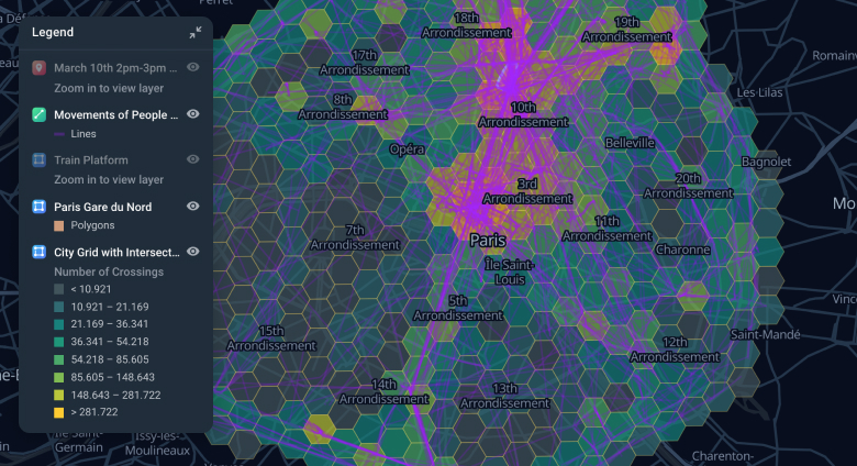
- The list of integrated datasets in the GIS system is growing. The new datasets are continuously added, for example, population mobility or weather data. Integrated data ensures that users will effortlessly leverage their power.
- Not all BI solutions support polygon shapes. However, a polygon is the main spatial entity used for analytics in construction, agricultural, and environmental industries.
- GIS excels at working with large volumes of spatial data. To compare, Power BI has a maximum of 3500 points per chart. What’s an analyst to do if she has 4000 points to enter?
- Another important aspect that sets GIS aside is the human factor. Businesses, especially the ones that invest in business intelligence tools, know too well the true cost of a human error. When the analyst has to examine one map instead of poring into eight different spreadsheets, the risk of human error significantly diminishes.
In many cases, GIS-powered business intelligence offers significant benefits across industries and applications. Improved efficiency, reduced costs, and better compliance are just some of the advantages to be expected. Whenever you work with geospatial data, GIS instruments complement BI and present the data in a practical, visual way. This results in a more comprehensive location intelligence data strategy.


