Business Solutions
All Industries
Public SafetyPublic Safety and COVID-19 HealthcareHealthcare RetailRetail EnvironmentSmart City Financial ServicesFinancial Services
Transport & LogisticsTransport & Logistics GovernmentGovernment Real EstateReal Estate EnvironmentEnvironment
Product Overview
Features Map Gallery Aspectum for Business Platform Security Aspectum vs Competitors User Guide API
Services
Data on Demand Custom Development Expert Sessions Technical Support
Pricing Blog About Us
Sign in My Account Sign up
User avatar
Personal settings Guide Sign out
Business Solution
Industries
Public SafetyPublic Safety and COVID-19 RetailHealthcare RetailRetail EnvironmentSmart City Financial ServicesFinancial Services Transport & LogisticsTransport & Logistics GovernmentGovernment Real EstateReal Estate EnvironmentEnvironment
Product Overview
Features Map Gallery Aspectum for Business Platform Security Aspectum vs Competitors User Guide API
Services
Data on Demand Custom Development Expert Sessions Technical Support
Pricing
Blog
About Us
Log out
Sign in Sign up

Map gallery for tourism sector

Deploy digital data-driven cartography to get the best area-based summary of the tourism sector development. Use geospatial information systems to visualize infrastructure level distribution, sightseeing locations, transport routes, weather conditions, and climate in the targeted area. Check out the gallery below to get a glimpse of the scope and capacity of the smart maps. GIS solutions are highly effective for tourists themselves, touring service providers, and industry researchers as well.

All AgroChemicalsConstructionEducationEnergyEngineeringEnvironmentFinancial ServiceForestryGovernmentalHealthcareHospitalityHumanitarianInfrastructureInsuranceManufacturingMaritimeMediaNGOOil & GasRaw MaterialsReal EstateRecreationRetailSecuritySmart CityTelecommunicationsTourismTransportation & LogisticsUrban Mobility
Places to stay in Singapore

Places to stay in Singapore

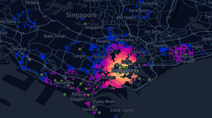
Where to stay in Singapore to see as many attractions within walking distance as possible?
Blue Flag Sites

Blue Flag Sites

The map collected information about the Blue Flag Sites across the globe.
Home Tourism
Business Solution
Industries
Public SafetyPublic Safety and COVID-19 RetailHealthcare RetailRetail EnvironmentSmart City Financial ServicesFinancial Services Transport & LogisticsTransport & Logistics GovernmentGovernment Real EstateReal Estate EnvironmentEnvironment
Product Overview
Features Map Gallery Aspectum for Business Platform Security Aspectum vs Competitors User Guide API
Services
Data on Demand Custom Development Expert Sessions Technical Support
Pricing
Blog
About Us
Log out
Sign in Sign up
Industries
Public Safety and COVID-19 Healthcare Retail Smart City Financial Services Transport & Logistics Government Real Estate Environment
Product Overview
Features Map Gallery Aspectum for Business Platform Security Pricing Aspectum vs Competitors User Guide API
Services
Data on Demand Custom Development Resellers Program Expert Sessions Technical Support
Blog
About Us
GIS Usage
Spatial Analysis Geocoding WebGIS GIS data What is GIS Location
Intelligence
Facebook Twitter GitHub LinkedIn YouTube
Privacy Policy Terms of Use
© Copyright 2021 Earth Observing System. All rights reserved.
This website uses cookies and also collects some information using analytics software to improve user experience.
By continuing to browse this website you accept the use of cookies. See Privacy Policy to know more about how we use cookies.