Business Solutions
All Industries
Public SafetyPublic Safety and COVID-19 HealthcareHealthcare RetailRetail EnvironmentSmart City Financial ServicesFinancial Services
Transport & LogisticsTransport & Logistics GovernmentGovernment Real EstateReal Estate EnvironmentEnvironment
Product Overview
Features Map Gallery Aspectum for Business Platform Security Aspectum vs Competitors User Guide API
Services
Data on Demand Custom Development Expert Sessions Technical Support
Pricing Blog About Us
Sign in My Account Sign up
User avatar
Personal settings Guide Sign out
Business Solution
Industries
Public SafetyPublic Safety and COVID-19 RetailHealthcare RetailRetail EnvironmentSmart City Financial ServicesFinancial Services Transport & LogisticsTransport & Logistics GovernmentGovernment Real EstateReal Estate EnvironmentEnvironment
Product Overview
Features Map Gallery Aspectum for Business Platform Security Aspectum vs Competitors User Guide API
Services
Data on Demand Custom Development Expert Sessions Technical Support
Pricing
Blog
About Us
Log out
Sign in Sign up

Humanitarian map gallery

Render the results of social researches and opinion surveys in the form of a digital multilayer map. Humanities-related GIS can include a broad variety of data useful for humanitarian organizations and citizens in general in emergency situations, highlighting water resources, light sources, accessible food sources, social buildings, etc. GIS can be used to cope with the sudden impact of crises or disasters, offering useful data for authorities and for regular people.

All AgroChemicalsConstructionEducationEnergyEngineeringEnvironmentFinancial ServiceForestryGovernmentalHealthcareHospitalityHumanitarianInfrastructureInsuranceManufacturingMaritimeMediaNGOOil & GasRaw MaterialsReal EstateRecreationRetailSecuritySmart CityTelecommunicationsTourismTransportation & LogisticsUrban Mobility
Free to Be – Lima

Free to Be – Lima

The map represents the information gathered by the "Free to Be" research.
Home Humanitarian
Business Solution
Industries
Public SafetyPublic Safety and COVID-19 RetailHealthcare RetailRetail EnvironmentSmart City Financial ServicesFinancial Services Transport & LogisticsTransport & Logistics GovernmentGovernment Real EstateReal Estate EnvironmentEnvironment
Product Overview
Features Map Gallery Aspectum for Business Platform Security Aspectum vs Competitors User Guide API
Services
Data on Demand Custom Development Expert Sessions Technical Support
Pricing
Blog
About Us
Log out
Sign in Sign up
Industries
Public Safety and COVID-19 Healthcare Retail Smart City Financial Services Transport & Logistics Government Real Estate Environment
Product Overview
Features Map Gallery Aspectum for Business Platform Security Pricing Aspectum vs Competitors User Guide API
Services
Data on Demand Custom Development Resellers Program Expert Sessions Technical Support
Blog
About Us
GIS Usage
Spatial Analysis Geocoding WebGIS GIS data What is GIS Location
Intelligence
Facebook Twitter GitHub LinkedIn YouTube
Privacy Policy Terms of Use
© Copyright 2021 Earth Observing System. All rights reserved.
This website uses cookies and also collects some information using analytics software to improve user experience.
By continuing to browse this website you accept the use of cookies. See Privacy Policy to know more about how we use cookies.
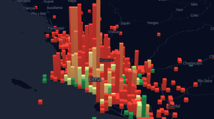